
Munro Hillwalk to Beinn na Lap, Meall Garbh, Chno Dearg and Stob Coire Sgriodain
- Distance: 25.1 Km
- Elevation gain: 1,321 m
- Maximum elevation: 1,046 m
- Elevation loss: 1,524 m
- Minimum elevation: 177 m
- Moving time: 7 h 29 m
- Moving speed: 3.4 Km/h
- Maximum speed: 33.8 Km/h
- Total time: 8 h 55 m
- Global speed: 2.8 Km/h
Interactive trail map
Trail profile
- Distance: 25.1 Km
- Elevation gain: 1,321 m
- Maximum elevation: 1,046 m
- Elevation loss: 1,524 m
- Minimum elevation: 177 m
- Moving time: 7 h 29 m
- Moving speed: 3.4 Km/h
- Maximum speed: 33.8 Km/h
- Total time: 8 h 55 m
- Global speed: 2.8 Km/h
About this trail
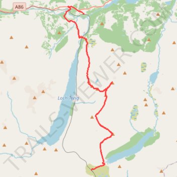
Name: Munro Hillwalk to Beinn na Lap, Meall Garbh, Chno Dearg and Stob Coire Sgriodain trail, distance, elevation, map, profile, GPS track
Start: The Road to the Isles, Highland, Scotland, United Kingdom (56.76049 -4.69064)
End: Highland, Scotland, PH31 4AR, United Kingdom (56.88426 -4.70125)
Coordinates: 56.76049 -4.73024 56.89013 -4.65998
Other hiking, mountain biking, running and outdoor activity trails
Click on a trail to view its statistics, map and profile.
Great Glen Way (Fort William to Fort Augustus)
United Kingdom > Scotland > Highland > Fort William
Distance: 52.6 Km • Elevation gain: 598 m • Maximum elevation: 108 m