Import a GPX file

Trace of the board walk at Six Mile Cypress Slough Preserve

  • Distance: 3.6 Km
  • Elevation gain: 5 m
  • Maximum elevation: 8 m
  • Elevation loss: 5 m
  • Minimum elevation: 5 m

Interactive trail map

Trail profile

  • Distance: 3.6 Km
  • Elevation gain: 5 m
  • Maximum elevation: 8 m
  • Elevation loss: 5 m
  • Minimum elevation: 5 m

About this trail
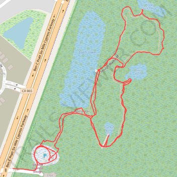
Name: Trace of the board walk at Six Mile Cypress Slough Preserve trail, distance, elevation, map, profile, GPS track

Start: Ben C Pratt Six Mile Cypress Parkway, Brookshire, Lee County, Florida, 33912, United States (26.57142 -81.82645)

End: Lee County, Florida, 33912, United States (26.57066 -81.82745)

Coordinates: 26.57060 -81.82745 26.57598 -81.82189

Gear up for your next adventure:

📦Outdoor Storage Bags - Keep gear organized and dry
🧊Winter Boot Traction - Grip for icy paths in the Mourne or Derryveagh mountains
🏃Men's Trail Runners - Grip and speed for rugged Irish mountain running
🔌Fast Car Chargers - Recharge GPS and phones between trailheads
🧺Waterproof Picnic Blankets - Dry seating for breaks on damp grass

As an Amazon Associate, this site earns from qualifying purchases at no extra cost to you.