
Bear Creek Falls Trail in Uncompahgre National Forest
The Bear Creek Trail, starting from Telluride, offers hikers a scenic journey through diverse landscapes. Along the way, you'll encounter dense forests, open meadows, and panoramic vistas of the surrounding rugged peaks of the San Juan Mountains. The trail culminates at the impressive Bear Creek Falls, where the cascading water provides a refreshing sight amidst the rugged terrain. #Hiking #Mountain #Forest #Nature #Waterfall
- Distance: 7.4 Km
- Elevation gain: 366 m
- Maximum elevation: 3,034 m
- Elevation loss: 373 m
- Minimum elevation: 2,679 m
- Moving time: 1 h 59 m
- Moving speed: 3.7 Km/h
- Maximum speed: 6.2 Km/h
- Total time: 2 h 39 m
- Global speed: 2.8 Km/h
Interactive trail map
Trail profile
- Distance: 7.4 Km
- Elevation gain: 366 m
- Maximum elevation: 3,034 m
- Elevation loss: 373 m
- Minimum elevation: 2,679 m
- Moving time: 1 h 59 m
- Moving speed: 3.7 Km/h
- Maximum speed: 6.2 Km/h
- Total time: 2 h 39 m
- Global speed: 2.8 Km/h
About this trail
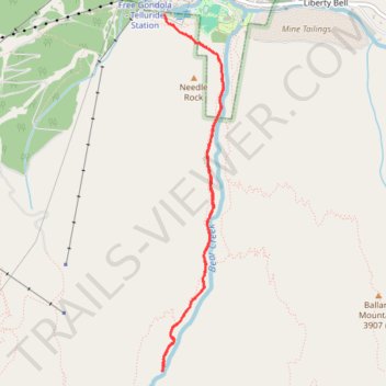
Name: Bear Creek Falls Trail in Uncompahgre National Forest trail, distance, elevation, map, profile, GPS track
Start: Bear Creek, Telluride, San Miguel County, Colorado, 81435, United States (37.93400 -107.81171)
End: Bear Creek, Telluride, San Miguel County, Colorado, 81435, United States (37.93432 -107.81191)
Coordinates: 37.90589 -107.81208 37.93432 -107.80589