
Picacho Peak Trail from Santa Fe Canyon Preserve
The Picacho Peak Trail offers a rewarding hike with a relatively moderate challenge. As you climb through juniper and pine forests, you'll be treated to increasingly expansive views, especially after the switchbacks near the top. The summit rewards you with stunning 360-degree vistas of Santa Fe and the surrounding landscape, making the effort well worth it. #Hiking #Mountain #Forest #Nature
- Distance: 6.3 Km
- Elevation gain: 386 m
- Maximum elevation: 2,592 m
- Elevation loss: 386 m
- Minimum elevation: 2,233 m
- Moving time: 1 h 47 m
- Moving speed: 3.5 Km/h
- Maximum speed: 7.0 Km/h
- Total time: 2 h 31 m
- Global speed: 2.5 Km/h
Interactive trail map
Trail profile
- Distance: 6.3 Km
- Elevation gain: 386 m
- Maximum elevation: 2,592 m
- Elevation loss: 386 m
- Minimum elevation: 2,233 m
- Moving time: 1 h 47 m
- Moving speed: 3.5 Km/h
- Maximum speed: 7.0 Km/h
- Total time: 2 h 31 m
- Global speed: 2.5 Km/h
About this trail
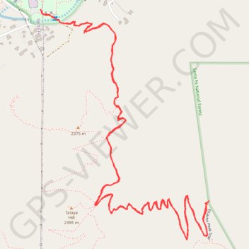
Name: Picacho Peak Trail from Santa Fe Canyon Preserve trail, distance, elevation, map, profile, GPS track
Start: Cerro Gordo Road, Santa Fe, Santa Fe County, New Mexico, 87501, United States (35.68651 -105.89506)
End: Cerro Gordo Road, Santa Fe, Santa Fe County, New Mexico, 87501, United States (35.68655 -105.89511)
Coordinates: 35.67703 -105.89511 35.68655 -105.88656