
Lily Pad Lake Trail in Eagles Nest Wilderness
The Lily Pad Lake Trail offers a peaceful and scenic experience through lush forests and alpine meadows. Hikers can enjoy the tranquil beauty of small ponds and two serene lakes surrounded by towering peaks, with expansive views of Buffalo Mountain. The relatively easy route, featuring forested areas and stream crossings, makes it a great choice to appreciate the serenity of nature. #Hiking #Mountain #Forest #Nature #Lake
- Distance: 5.0 Km
- Elevation gain: 107 m
- Maximum elevation: 3,043 m
- Elevation loss: 104 m
- Minimum elevation: 2,991 m
- Moving time: 1 h 15 m
- Moving speed: 4.0 Km/h
- Maximum speed: 6.6 Km/h
- Total time: 1 h 30 m
- Global speed: 3.3 Km/h
Interactive trail map
Trail profile
- Distance: 5.0 Km
- Elevation gain: 107 m
- Maximum elevation: 3,043 m
- Elevation loss: 104 m
- Minimum elevation: 2,991 m
- Moving time: 1 h 15 m
- Moving speed: 4.0 Km/h
- Maximum speed: 6.6 Km/h
- Total time: 1 h 30 m
- Global speed: 3.3 Km/h
About this trail
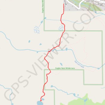
Name: Lily Pad Lake Trail in Eagles Nest Wilderness trail, distance, elevation, map, profile, GPS track
Start: Lily Pad Lake Trail, Wildernest, Summit County, Colorado, 80498, United States (39.61804 -106.11045)
End: Lily Pad Lake Trail, Wildernest, Summit County, Colorado, 80498, United States (39.61792 -106.11052)
Coordinates: 39.60018 -106.11609 39.61804 -106.11025