
Sky Bridge Loop Trail in Red River Gorge Geological Area
The Sky Bridge Trail offers a blend of accessibility and thrilling views, ideal for hikers of all skill levels. Starting with a paved, level path to the top of the natural stone arch, hikers enjoy sweeping views of the gorge before descending stairs to explore beneath the arch itself. With its mix of rugged cliff edges, forested scenery, and open vistas along a well-marked route, this trail is a compact yet memorable highlight in the Daniel Boone National Forest. #Hiking #Loop #Arch #Gorge #Cliff #Rock #Forest #Nature
- Distance: 1.2 Km
- Elevation gain: 71 m
- Maximum elevation: 343 m
- Elevation loss: 72 m
- Minimum elevation: 276 m
- Moving time: 16 m 45 s
- Moving speed: 4.2 Km/h
- Maximum speed: 8.0 Km/h
- Total time: 23 m 42 s
- Global speed: 3.0 Km/h
Interactive trail map
Trail profile
- Distance: 1.2 Km
- Elevation gain: 71 m
- Maximum elevation: 343 m
- Elevation loss: 72 m
- Minimum elevation: 276 m
- Moving time: 16 m 45 s
- Moving speed: 4.2 Km/h
- Maximum speed: 8.0 Km/h
- Total time: 23 m 42 s
- Global speed: 3.0 Km/h
About this trail
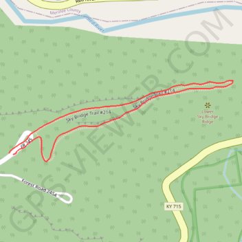
Name: Sky Bridge Loop Trail in Red River Gorge Geological Area trail, distance, elevation, map, profile, GPS track
Start: Sky Bridge Road, Wolfe County, Kentucky, United States (37.81770 -83.58257)
End: Sky Bridge Road, Wolfe County, Kentucky, United States (37.81767 -83.58247)
Coordinates: 37.81753 -83.58257 37.81915 -83.57691