Thank you for supporting this site ❤️
Make a donation
Make a donation
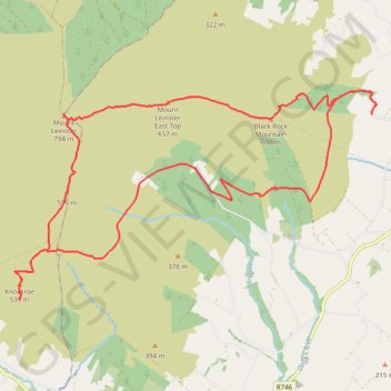
Loop route up over Mount Leinster
Mount Leinster Loop
- Distance: 22.8 Km
- Elevation gain: 880 m
- Maximum elevation: 789 m
- Elevation loss: 880 m
- Minimum elevation: 210 m
- Moving time: 5 h 3 m
- Moving speed: 4.5 Km/h
- Maximum speed: 8.4 Km/h
- Total time: 6 h 33 m
- Global speed: 3.5 Km/h
Interactive trail map
Thank you for supporting this site ❤️
Make a donation
Make a donation
Trail profile
- Distance: 22.8 Km
- Elevation gain: 880 m
- Maximum elevation: 789 m
- Elevation loss: 880 m
- Minimum elevation: 210 m
- Moving time: 5 h 3 m
- Moving speed: 4.5 Km/h
- Maximum speed: 8.4 Km/h
- Total time: 6 h 33 m
- Global speed: 3.5 Km/h
Thank you for supporting this site ❤️
Make a donation
Make a donation
About this trail
Name: Loop route up over Mount Leinster trail, distance, elevation, map, profile, GPS track
Coordinates: 52.58971 -6.79275 52.62194 -6.70124
Topography: County Wexford topographic map, elevation, terrain
Thank you for supporting this site ❤️
Make a donation
Make a donation