Thank you for supporting this site ❤️
Make a donation
Make a donation
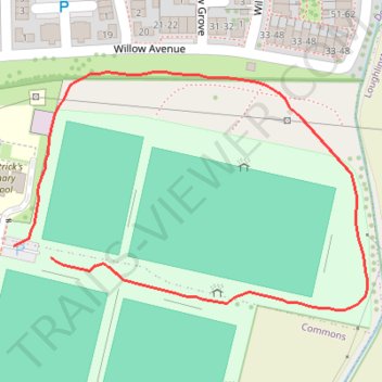
Celbridge GAA walkway
- Distance: 0.7 Km
- Elevation gain: 2 m
- Maximum elevation: 57 m
- Elevation loss: 2 m
- Minimum elevation: 55 m
- Moving time: 9 m 35 s
- Moving speed: 4.5 Km/h
- Maximum speed: 7.3 Km/h
- Total time: 9 m 35 s
- Global speed: 4.5 Km/h
Interactive trail map
Thank you for supporting this site ❤️
Make a donation
Make a donation
Trail profile
- Distance: 0.7 Km
- Elevation gain: 2 m
- Maximum elevation: 57 m
- Elevation loss: 2 m
- Minimum elevation: 55 m
- Moving time: 9 m 35 s
- Moving speed: 4.5 Km/h
- Maximum speed: 7.3 Km/h
- Total time: 9 m 35 s
- Global speed: 4.5 Km/h
Thank you for supporting this site ❤️
Make a donation
Make a donation
About this trail
Name: Celbridge GAA walkway trail, distance, elevation, map, profile, GPS track
Coordinates: 53.33169 -6.52825 53.33329 -6.52427
Topography: County Kildare topographic map, elevation, terrain
Thank you for supporting this site ❤️
Make a donation
Make a donation