Swan View Tunnel and Falls
John Forrest National Park. #Hiking #Loop #JohnForrest
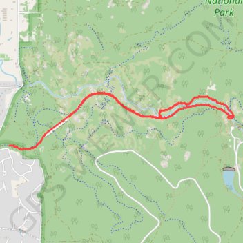
- Distance: 5.8 Km
- Elevation gain: 102 m
- Maximum elevation: 148 m
- Elevation loss: 87 m
- Minimum elevation: 90 m
- Moving time: 1 h 32 m
- Moving speed: 3.8 Km/h
- Maximum speed: 9.2 Km/h
- Total time: 1 h 47 m
- Global speed: 3.3 Km/h
Interactive trail map
Trail profile
- Distance: 5.8 Km
- Elevation gain: 102 m
- Maximum elevation: 148 m
- Elevation loss: 87 m
- Minimum elevation: 90 m
- Moving time: 1 h 32 m
- Moving speed: 3.8 Km/h
- Maximum speed: 9.2 Km/h
- Total time: 1 h 47 m
- Global speed: 3.3 Km/h
About this trail
Name: Swan View Tunnel and Falls trail, distance, elevation, map, profile, GPS track
Coordinates: -31.88572 116.06329 -31.87948 116.09247
Other hiking, mountain biking, running and outdoor activity trails
Click on a trail to view its statistics, map and profile.
Kep 75k
Distance: 76.6 Km • Elevation gain: 899 m • Maximum elevation: 310 m
Railway Reserves Heritage North Trail and Eagle View Track
Distance: 16.3 Km • Elevation gain: 359 m • Maximum elevation: 237 m
Railway Reserves Heritage Trail
Distance: 42.9 Km • Elevation gain: 390 m • Maximum elevation: 323 m
Kep 100k
Distance: 104.1 Km • Elevation gain: 1,034 m • Maximum elevation: 322 m
2021 Toodyay return via Kep
Distance: 229.9 Km • Elevation gain: 1,859 m • Maximum elevation: 357 m