
Sawmill Reservoir Loop
The Sawmill Reservoir Loop in Breckenridge offers a peaceful and scenic hike, ideal for visitors seeking a short, accessible route near the town. As you traverse the well-maintained path, you'll enjoy views of the tranquil reservoir, surrounded by towering pines and open meadows, with occasional glimpses of distant mountain peaks. Along the trail, you might spot wildlife such as moose or deer, and there are benches available for resting while taking in the serene atmosphere of this picturesque setting. #Hiking #Lake #Forest #Nature #Loop
- Distance: 2.1 Km
- Elevation gain: 71 m
- Maximum elevation: 3,033 m
- Elevation loss: 78 m
- Minimum elevation: 2,954 m
- Moving time: 27 m 55 s
- Moving speed: 4.5 Km/h
- Maximum speed: 6.5 Km/h
- Total time: 29 m 30 s
- Global speed: 4.3 Km/h
Interactive trail map
Trail profile
- Distance: 2.1 Km
- Elevation gain: 71 m
- Maximum elevation: 3,033 m
- Elevation loss: 78 m
- Minimum elevation: 2,954 m
- Moving time: 27 m 55 s
- Moving speed: 4.5 Km/h
- Maximum speed: 6.5 Km/h
- Total time: 29 m 30 s
- Global speed: 4.3 Km/h
About this trail
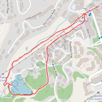
Name: Sawmill Reservoir Loop trail, distance, elevation, map, profile, GPS track
Start: Four O'Clock Road, Breckenridge, Summit County, Colorado, 80424, United States (39.47850 -106.05285)
Coordinates: 39.47319 -106.05997 39.47903 -106.05189