Thank you for supporting this site ❤️
Make a donation
Make a donation
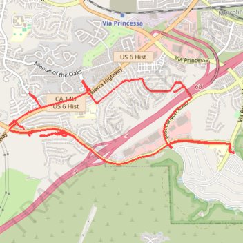
Evening Ride
- Distance: 10.8 Km
- Elevation gain: 282 m
- Maximum elevation: 569 m
- Elevation loss: 282 m
- Minimum elevation: 453 m
- Moving time: 51 m 44 s
- Moving speed: 12.6 Km/h
- Maximum speed: 51.3 Km/h
- Total time: 53 m 27 s
- Global speed: 12.2 Km/h
Interactive trail map
Thank you for supporting this site ❤️
Make a donation
Make a donation
Trail profile
- Distance: 10.8 Km
- Elevation gain: 282 m
- Maximum elevation: 569 m
- Elevation loss: 282 m
- Minimum elevation: 453 m
- Moving time: 51 m 44 s
- Moving speed: 12.6 Km/h
- Maximum speed: 51.3 Km/h
- Total time: 53 m 27 s
- Global speed: 12.2 Km/h
Thank you for supporting this site ❤️
Make a donation
Make a donation
About this trail
Name: Evening Ride trail, distance, elevation, map, profile, GPS track
Coordinates: 34.39138 -118.48500 34.40120 -118.45379
Thank you for supporting this site ❤️
Make a donation
Make a donation