Import a GPX file

White Oak Falls and Cedar Run Falls Loop

Shenandoah National Park. White Oak Canyon. #Hiking #Loop #Waterfall #River #Mountain #Forest #Nature

  • Distance: 14.2 Km
  • Elevation gain: 743 m
  • Maximum elevation: 1,021 m
  • Elevation loss: 742 m
  • Minimum elevation: 341 m

Interactive trail map

Trail profile

  • Distance: 14.2 Km
  • Elevation gain: 743 m
  • Maximum elevation: 1,021 m
  • Elevation loss: 742 m
  • Minimum elevation: 341 m

About this trail
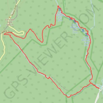
Name: White Oak Falls and Cedar Run Falls Loop trail, distance, elevation, map, profile, GPS track

Start: Whiteoak Boundary Parking, Weakley Hollow Road, Madison County, Virginia, 22743, United States (38.53906 -78.34808)

End: Whiteoak Boundary Parking, Weakley Hollow Road, Madison County, Virginia, 22743, United States (38.53907 -78.34812)

Coordinates: 38.53633 -78.38588 38.56477 -78.34808

Other hiking, mountain biking, running and outdoor activity trails

Click on a trail to view its statistics, map and profile.
Gear up for your next adventure:

🧴Anti-Chafe Sticks - Prevent friction during long distance walking
🧯Compact Fire Extinguishers - Safety for campervans and expedition vehicles
🧺Quick-Dry Hiking Towels - Space-saving towels for wild swimming or camping
🔥Compact Camping Stoves - Fast-boil stoves for trail-side meals and coffee
🧊Hydration Reservoirs - Easy drinking on the move with 2L or 3L bladders

As an Amazon Associate, this site earns from qualifying purchases at no extra cost to you.