Thank you for supporting this site ❤️
Make a donation
Make a donation
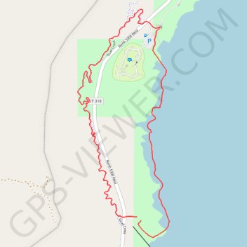
Quail Creek bike trail and beach
- Distance: 3.6 Km
- Elevation gain: 80 m
- Maximum elevation: 955 m
- Elevation loss: 77 m
- Minimum elevation: 909 m
- Moving time: 1 h 5 m
- Moving speed: 3.3 Km/h
- Maximum speed: 5.6 Km/h
- Total time: 1 h 9 m
- Global speed: 3.1 Km/h
Interactive trail map
Thank you for supporting this site ❤️
Make a donation
Make a donation
Trail profile
- Distance: 3.6 Km
- Elevation gain: 80 m
- Maximum elevation: 955 m
- Elevation loss: 77 m
- Minimum elevation: 909 m
- Moving time: 1 h 5 m
- Moving speed: 3.3 Km/h
- Maximum speed: 5.6 Km/h
- Total time: 1 h 9 m
- Global speed: 3.1 Km/h
Thank you for supporting this site ❤️
Make a donation
Make a donation
About this trail
Name: Quail Creek bike trail and beach trail, distance, elevation, map, profile, GPS track
Start: North 5300 West, Hurricane, Washington County, Utah, United States (37.17891 -113.39498)
End: North 5300 West, Hurricane, Washington County, Utah, United States (37.17909 -113.39521)
Coordinates: 37.17809 -113.39876 37.18897 -113.39329
Thank you for supporting this site ❤️
Make a donation
Make a donation