Import a GPX file

Halle Ravine Nature Preserve and Pine Terrace Preserve loop trails

  • Distance: 2.9 Km
  • Elevation gain: 69 m
  • Maximum elevation: 171 m
  • Elevation loss: 69 m
  • Minimum elevation: 128 m
  • Moving time: 42 m 20 s
  • Moving speed: 4.1 Km/h
  • Maximum speed: 7.7 Km/h
  • Total time: 44 m 35 s
  • Global speed: 3.9 Km/h

Interactive trail map

Trail profile

  • Distance: 2.9 Km
  • Elevation gain: 69 m
  • Maximum elevation: 171 m
  • Elevation loss: 69 m
  • Minimum elevation: 128 m
  • Moving time: 42 m 20 s
  • Moving speed: 4.1 Km/h
  • Maximum speed: 7.7 Km/h
  • Total time: 44 m 35 s
  • Global speed: 3.9 Km/h

About this trail
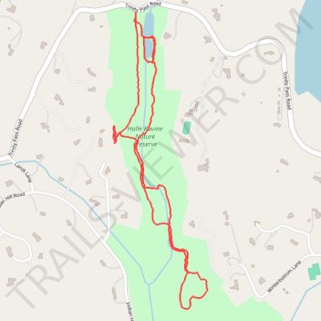
Name: Halle Ravine Nature Preserve and Pine Terrace Preserve loop trails trail, distance, elevation, map, profile, GPS track

Start: 235, Trinity Pass Road, Scotts Corners, Town of Pound Ridge, Westchester County, New York, 10576, United States (41.21686 -73.56244)

End: 235, Trinity Pass Road, Scotts Corners, Town of Pound Ridge, Westchester County, New York, 10576, United States (41.21685 -73.56246)

Coordinates: 41.20800 -73.56334 41.21686 -73.55963

Other hiking, mountain biking, running and outdoor activity trails

Click on a trail to view its statistics, map and profile.
Montréal - New York

Canada > Quebec > Urban agglomeration of Montreal > Montreal

#Bike #Montréal #NewYork

Distance: 637.6 Km • Elevation gain: 4,860 m • Maximum elevation: 301 m

Gear up for your next adventure:

🦯Lightweight Trekking Poles - Reduce knee strain on steep Wicklow or Kerry slopes
🧯Campfire Safety Gear - Gear to safely manage fires
🛡️Protective Bike Gear - Helmets & pads for safe rides
🧗Rock Climbing Gear - Essentials for the cliffs of Moher or Gap of Dunloe
🚶‍♂️Trekking Poles - Supportive poles for stability on varied terrain

As an Amazon Associate, this site earns from qualifying purchases at no extra cost to you.