Thank you for supporting this site ❤️
Make a donation
Make a donation
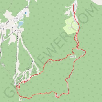
덕유산 칠봉코스
- Distance: 17.0 Km
- Elevation gain: 1,087 m
- Maximum elevation: 1,602 m
- Elevation loss: 1,081 m
- Minimum elevation: 599 m
- Moving time: 5 h 25 m
- Moving speed: 3.1 Km/h
- Maximum speed: 7.4 Km/h
- Total time: 8 h 22 m
- Global speed: 2.0 Km/h
Interactive trail map
Thank you for supporting this site ❤️
Make a donation
Make a donation
Trail profile
- Distance: 17.0 Km
- Elevation gain: 1,087 m
- Maximum elevation: 1,602 m
- Elevation loss: 1,081 m
- Minimum elevation: 599 m
- Moving time: 5 h 25 m
- Moving speed: 3.1 Km/h
- Maximum speed: 7.4 Km/h
- Total time: 8 h 22 m
- Global speed: 2.0 Km/h
Thank you for supporting this site ❤️
Make a donation
Make a donation
About this trail
Name: 덕유산 칠봉코스 trail, distance, elevation, map, profile, GPS track
Start: 구천동1로, Seolcheon-myeon, Muju-gun, Jeonbuk State, South Korea (35.90104 127.77591)
Coordinates: 35.85915 127.74419 35.90104 127.78225
Thank you for supporting this site ❤️
Make a donation
Make a donation