Import a GPX file

Two Trees and Mount Tralala Hiking Tour from Malaybalay

  • Distance: 7.1 Km
  • Elevation gain: 286 m
  • Maximum elevation: 785 m
  • Elevation loss: 285 m
  • Minimum elevation: 586 m
  • Moving time: 1 h 49 m
  • Moving speed: 3.9 Km/h
  • Maximum speed: 10.2 Km/h
  • Total time: 2 h 4 m
  • Global speed: 3.4 Km/h

Interactive trail map

Trail profile

  • Distance: 7.1 Km
  • Elevation gain: 286 m
  • Maximum elevation: 785 m
  • Elevation loss: 285 m
  • Minimum elevation: 586 m
  • Moving time: 1 h 49 m
  • Moving speed: 3.9 Km/h
  • Maximum speed: 10.2 Km/h
  • Total time: 2 h 4 m
  • Global speed: 3.4 Km/h

About this trail
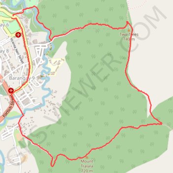
Name: Two Trees and Mount Tralala Hiking Tour from Malaybalay trail, distance, elevation, map, profile, GPS track

Start: San Victores Street, Barangay 6, Malaybalay, Bukidnon, Northern Mindanao, 8700, Philippines (8.15663 125.13218)

End: Judge P. Carillo Street, Barangay 6, Malaybalay, Bukidnon, Northern Mindanao, 8700, Philippines (8.15634 125.13200)

Coordinates: 8.14080 125.13195 8.15762 125.14795

Gear up for your next adventure:

💧Portable Water Filters - Safe drinking water from streams and lakes
⌚Solar Multisport Watches - Advanced mapping and GPS tracking for endurance hikers
🛠️Tent Repair Kits - Fix tents on the trail
🗺️Irish Road Atlases - Comprehensive physical maps for road trips and navigation
📍Handheld GPS Devices - Accurate GPS units for mapping and navigation

As an Amazon Associate, this site earns from qualifying purchases at no extra cost to you.