
Mount Rubidoux
From the Glenwood Drive entrance, the loop follows Mount Rubidoux’s paved park road through open, boulder-strewn slopes above the Santa Ana River.
It climbs past the Peace Tower and Friendship Bridge to the summit area, where the Serra Cross, flag, historic plaques, and broad Riverside views form the route’s main highlight.
The return curves down the outer hillside, with city, river, and mountain views before rejoining the lower park path.
#Hiking #Loop #Mountain #Nature #River
- Distance: 4.8 Km
- Elevation gain: 177 m
- Maximum elevation: 391 m
- Elevation loss: 177 m
- Minimum elevation: 260 m
Interactive trail map
Trail profile
- Distance: 4.8 Km
- Elevation gain: 177 m
- Maximum elevation: 391 m
- Elevation loss: 177 m
- Minimum elevation: 260 m
About this trail
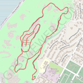
Name: Mount Rubidoux trail, distance, elevation, map, profile, GPS track
Coordinates: 33.97941 -117.39465 33.98780 -117.38762
Other hiking, mountain biking, running and outdoor activity trails
Click on a trail to view its statistics, map and profile.
Butterfly conservation at Rubidoux
United States > California > Riverside County > Riverside
Distance: 0.8 Km • Elevation gain: 9 m • Maximum elevation: 268 m