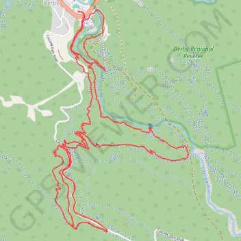
MTB - Derby
- Distance: 13.5 Km
- Elevation gain: 486 m
- Maximum elevation: 412 m
- Elevation loss: 486 m
- Minimum elevation: 148 m
- Moving time: 1 h 15 m
- Moving speed: 10.7 Km/h
- Maximum speed: 36.3 Km/h
- Total time: 1 h 42 m
- Global speed: 7.9 Km/h
Interactive trail map
Trail profile
- Distance: 13.5 Km
- Elevation gain: 486 m
- Maximum elevation: 412 m
- Elevation loss: 486 m
- Minimum elevation: 148 m
- Moving time: 1 h 15 m
- Moving speed: 10.7 Km/h
- Maximum speed: 36.3 Km/h
- Total time: 1 h 42 m
- Global speed: 7.9 Km/h
About this trail
Name: MTB - Derby trail, distance, elevation, map, profile, GPS track
Start: Main Street, Derby, Dorset, Tasmania, 7264, Australia (-41.14975 147.80390)
End: Main Street, Derby, Dorset, Tasmania, 7264, Australia (-41.14980 147.80390)
Coordinates: -41.16771 147.80111 -41.14957 147.81581
Other hiking, mountain biking, running and outdoor activity trails
Click on a trail to view its statistics, map and profile.
MTB - Derby - Longshadows upper and 333 down
Distance: 12.7 Km • Elevation gain: 390 m • Maximum elevation: 421 m