Thank you for supporting this site ❤️
Make a donation
Make a donation
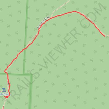
GoMap__2026_04_11__14_17_52
- Distance: 1.1 Km
- Elevation gain: 38 m
- Maximum elevation: 314 m
- Elevation loss: 2 m
- Minimum elevation: 276 m
- Moving time: 16 m 10 s
- Moving speed: 4.1 Km/h
- Maximum speed: 8.0 Km/h
- Total time: 17 m 2 s
- Global speed: 3.9 Km/h
Interactive trail map
Thank you for supporting this site ❤️
Make a donation
Make a donation
Trail profile
- Distance: 1.1 Km
- Elevation gain: 38 m
- Maximum elevation: 314 m
- Elevation loss: 2 m
- Minimum elevation: 276 m
- Moving time: 16 m 10 s
- Moving speed: 4.1 Km/h
- Maximum speed: 8.0 Km/h
- Total time: 17 m 2 s
- Global speed: 3.9 Km/h
Thank you for supporting this site ❤️
Make a donation
Make a donation
About this trail
Name: GoMap__2026_04_11__14_17_52 trail, distance, elevation, map, profile, GPS track
Start: Ash Gorge Trail, Benton Township, Hocking County, Ohio, United States (39.39899 -82.54433)
End: Buckeye Trail, Benton Township, Hocking County, Ohio, United States (39.40233 -82.53711)
Coordinates: 39.39894 -82.54433 39.40372 -82.53711
Thank you for supporting this site ❤️
Make a donation
Make a donation
Other hiking, mountain biking, running and outdoor activity trails
Click on a trail to view its statistics, map and profile.
GoMap__2026_04_11__17_31_37
United States > Ohio > Hocking County
Distance: 21.9 Km • Elevation gain: 237 m • Maximum elevation: 256 m
GoMap__2026_04_11__17_01_07
United States > Ohio > Hocking County
Distance: 1.7 Km • Elevation gain: 3 m • Maximum elevation: 324 m