Import a GPX file

Lyons Green View Point Park

  • Distance: 0.7 Km
  • Elevation gain: 35 m
  • Maximum elevation: 235 m
  • Elevation loss: 37 m
  • Minimum elevation: 202 m
  • Moving time: 17 m 12 s
  • Moving speed: 2.5 Km/h
  • Maximum speed: 8.6 Km/h
  • Total time: 29 m 47 s
  • Global speed: 1.5 Km/h

Interactive trail map

Trail profile

  • Distance: 0.7 Km
  • Elevation gain: 35 m
  • Maximum elevation: 235 m
  • Elevation loss: 37 m
  • Minimum elevation: 202 m
  • Moving time: 17 m 12 s
  • Moving speed: 2.5 Km/h
  • Maximum speed: 8.6 Km/h
  • Total time: 29 m 47 s
  • Global speed: 1.5 Km/h

About this trail
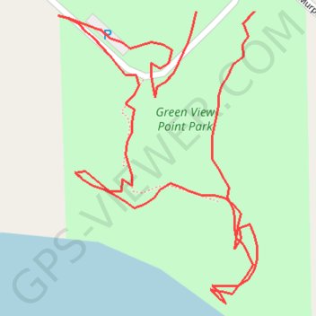
Name: Lyons Green View Point Park trail, distance, elevation, map, profile, GPS track

Start: 7998, Kimball Road, Lyons, Lyons Township, Ionia County, Michigan, 48851, United States (42.98722 -84.91961)

End: Kimball Road, Lyons, Lyons Township, Ionia County, Michigan, 48851, United States (42.98722 -84.92000)

Coordinates: 42.98579 -84.92092 42.98722 -84.91959

Gear up for your next adventure:

🛶Kayaking & Water Sports Gear - Equip for water adventures
🛌Cold Weather Sleeping Bags - Warm sleeping bags for colder hikes
📱Phone Holders for Biking - Secure phone mounts for touring cyclists
🔒Outdoor Gear Locks - Secure your equipment
🚰Portable Water Filters - Safely drink from Irish streams and mountain lakes

As an Amazon Associate, this site earns from qualifying purchases at no extra cost to you.