
Gray's Arch Loop via Rush Ridge Trail, Rough Trail and Gray's Arch Trail
The Gray's Arch Loop offers a stunning and moderately challenging hike through the iconic Red River Gorge, incorporating a mix of forested trails and panoramic views. Key highlights include the towering Gray's Arch, the varied rock formations along Rough Trail, and the expansive vistas from Rush Ridge Trail. The trail’s combination of downhill and uphill sections, along with creek crossings and rugged terrain, provides both scenic rewards and physical challenge, making it a memorable journey for those seeking both natural beauty and a bit of adventure. #Hiking #Loop #Rock #Arch #Forest #Nature
- Distance: 5.9 Km
- Elevation gain: 196 m
- Maximum elevation: 390 m
- Elevation loss: 196 m
- Minimum elevation: 271 m
- Moving time: 1 h 59 m
- Moving speed: 3.0 Km/h
- Maximum speed: 6.0 Km/h
- Total time: 2 h 39 m
- Global speed: 2.2 Km/h
Interactive trail map
Trail profile
- Distance: 5.9 Km
- Elevation gain: 196 m
- Maximum elevation: 390 m
- Elevation loss: 196 m
- Minimum elevation: 271 m
- Moving time: 1 h 59 m
- Moving speed: 3.0 Km/h
- Maximum speed: 6.0 Km/h
- Total time: 2 h 39 m
- Global speed: 2.2 Km/h
About this trail
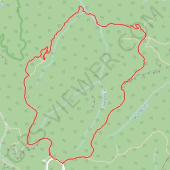
Name: Gray's Arch Loop via Rush Ridge Trail, Rough Trail and Gray's Arch Trail trail, distance, elevation, map, profile, GPS track
Start: Gray's Arch Trail, Powell County, Kentucky, 40376, United States (37.80834 -83.65756)
End: Gray's Arch Trail, Powell County, Kentucky, 40376, United States (37.80812 -83.65765)
Coordinates: 37.80733 -83.66063 37.82214 -83.64611
Other hiking, mountain biking, running and outdoor activity trails
Click on a trail to view its statistics, map and profile.
Gray's Arch Trail in Red River Gorge Geological Area
United States > Kentucky > Powell County
Gray's Arch Trail offers a moderate and scenic hike through the stunning Red River Gorge, famous for its remarkable natural arches and geological features. Along the trail, hikers are treated to the sight of Gray's Arch, a massive sandstone arch, and during the spring or after heavy rains, a picturesque…
Distance: 4.0 Km • Elevation gain: 131 m • Maximum elevation: 390 m