Adams Canyon Trail in Uinta-Wasatch-Cache National Forest
The Adams Canyon Trail in the Uinta-Wasatch-Cache National Forest offers hikers a rewarding journey through diverse landscapes. The path begins with a series of sandy switchbacks, leading to shaded areas where the trail follows the North Fork of Holmes Creek, passing through scrub oak and majestic white pines. Along the way, hikers can enjoy several small waterfalls and rugged rock outcroppings, culminating at the impressive Adams Canyon Waterfall, where a refreshing mist awaits. #Hiking #Canyon #Forest #Nature #Waterfall #River
- Distance: 5.7 Km
- Elevation gain: 421 m
- Maximum elevation: 1,894 m
- Elevation loss: 420 m
- Minimum elevation: 1,473 m
- Moving time: 1 h 27 m
- Moving speed: 3.9 Km/h
- Maximum speed: 6.8 Km/h
- Total time: 1 h 50 m
- Global speed: 3.1 Km/h
Interactive trail map
Trail profile
- Distance: 5.7 Km
- Elevation gain: 421 m
- Maximum elevation: 1,894 m
- Elevation loss: 420 m
- Minimum elevation: 1,473 m
- Moving time: 1 h 27 m
- Moving speed: 3.9 Km/h
- Maximum speed: 6.8 Km/h
- Total time: 1 h 50 m
- Global speed: 3.1 Km/h
About this trail
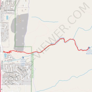
Name: Adams Canyon Trail in Uinta-Wasatch-Cache National Forest trail, distance, elevation, map, profile, GPS track
Coordinates: 41.06610 -111.90948 41.06933 -111.88529
Other hiking, mountain biking, running and outdoor activity trails
Click on a trail to view its statistics, map and profile.