Import a GPX file

Brundall & Blofield loop walk

walking, brundall, blofield

  • Distance: 11.1 Km
  • Elevation gain: 90 m
  • Maximum elevation: 25 m
  • Elevation loss: 90 m
  • Minimum elevation: 1 m
  • Moving time: 2 h 44 m
  • Moving speed: 4.1 Km/h
  • Maximum speed: 9.5 Km/h
  • Total time: 3 h 1 m
  • Global speed: 3.7 Km/h

Interactive trail map

Trail profile

  • Distance: 11.1 Km
  • Elevation gain: 90 m
  • Maximum elevation: 25 m
  • Elevation loss: 90 m
  • Minimum elevation: 1 m
  • Moving time: 2 h 44 m
  • Moving speed: 4.1 Km/h
  • Maximum speed: 9.5 Km/h
  • Total time: 3 h 1 m
  • Global speed: 3.7 Km/h

About this trail
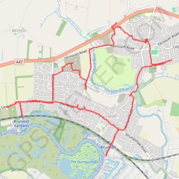
Name: Brundall & Blofield loop walk trail, distance, elevation, map, profile, GPS track

Start: Postwick Lane, Brundall, Witton, Broadland, Norfolk, England, NR13 5DT, United Kingdom (52.62465 1.41469)

End: Postwick Lane, Brundall, Witton, Broadland, Norfolk, England, NR13 5DT, United Kingdom (52.62464 1.41473)

Coordinates: 52.61758 1.41469 52.63680 1.45379

Gear up for your next adventure:

⛺Camping Tents - Top tents for Irish weather and conditions
🗺️Topographic Maps - Detailed maps for hiking, cycling and planning routes
🔋Solar Power Banks - Keep your GPS and phone charged in the Irish wilderness
🧢Waterproof Caps - Keep rain off your face and glasses while hiking
🥾Mountaineering Boots - Heavy‑duty boots for rugged peaks

As an Amazon Associate, this site earns from qualifying purchases at no extra cost to you.