Fort to Fort Trail
Bedford Channel, Fraser River, Salmon River Natural Area, Derby Reach Regional Park. #Hiking #DerbyReach
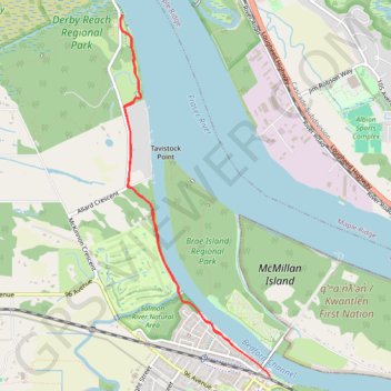
- Distance: 7.8 Km
- Elevation gain: 59 m
- Maximum elevation: 22 m
- Elevation loss: 59 m
- Minimum elevation: 4 m
Interactive trail map
Trail profile
- Distance: 7.8 Km
- Elevation gain: 59 m
- Maximum elevation: 22 m
- Elevation loss: 59 m
- Minimum elevation: 4 m
About this trail
Name: Fort to Fort Trail trail, distance, elevation, map, profile, GPS track
Coordinates: 49.17046 -122.59394 49.19906 -122.57580
Other hiking, mountain biking, running and outdoor activity trails
Click on a trail to view its statistics, map and profile.