
Mount Ida Trail from Milner Pass in Rocky Mountain National Park
The Mount Ida Trail offers a rewarding hike along the Continental Divide. Beginning near Poudre Lake, the route transitions from serene subalpine forests to expansive alpine tundra, revealing stunning vistas of the Never Summer Mountains and distant peaks like Longs Peak. The final stretch to the summit, while rugged and requiring some route-finding, is worth the effort for panoramic views that include Azure and Inkwell Lakes nestled far below. #Hiking #Mountain #Forest #Nature #Overlook #Ridge #Lake
- Distance: 16.0 Km
- Elevation gain: 834 m
- Maximum elevation: 3,914 m
- Elevation loss: 836 m
- Minimum elevation: 3,279 m
Interactive trail map
Trail profile
- Distance: 16.0 Km
- Elevation gain: 834 m
- Maximum elevation: 3,914 m
- Elevation loss: 836 m
- Minimum elevation: 3,279 m
About this trail
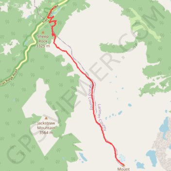
Name: Mount Ida Trail from Milner Pass in Rocky Mountain National Park trail, distance, elevation, map, profile, GPS track
Start: Trail Ridge Road, Larimer County, Colorado, United States (40.42301 -105.80985)
End: Trail Ridge Road, Larimer County, Colorado, United States (40.42413 -105.80820)
Coordinates: 40.37210 -105.81160 40.42413 -105.77878