Import a GPX file

Treen - Logan Rock - Porthcurno - Rospletha Cliff - Porth Chapel - Cox Cliff - Porthgwarra

Cornwall National Landscape Loop Walk

  • Distance: 11.7 Km
  • Elevation gain: 393 m
  • Maximum elevation: 93 m
  • Elevation loss: 394 m
  • Minimum elevation: 0 m

Interactive trail map

Trail profile

  • Distance: 11.7 Km
  • Elevation gain: 393 m
  • Maximum elevation: 93 m
  • Elevation loss: 394 m
  • Minimum elevation: 0 m

About this trail
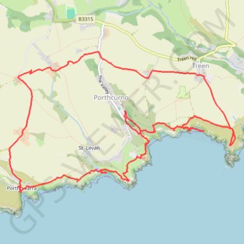
Name: Treen - Logan Rock - Porthcurno - Rospletha Cliff - Porth Chapel - Cox Cliff - Porthgwarra trail, distance, elevation, map, profile, GPS track

Start: Treen Chapel, Footpath Treen to Logan Rock, St. Levan, Penzance, Cornwall, England, TR19 6LF, United Kingdom (50.04975 -5.64124)

End: Treen car park, Footpath Treen to Logan Rock, St. Levan, Treen, Cornwall, England, TR19 6LF, United Kingdom (50.04991 -5.64108)

Coordinates: 50.03723 -5.67433 50.05264 -5.63587

Gear up for your next adventure:

🔦UV Flashlights - Search for minerals or inspect maps at night
🧦Merino Wool Socks - Moisture-wicking and blister-preventing trail socks
🥾Lightweight Hiking Shoes - Light, breathable shoes for trail walking
🎒Surveyor High-Vis Vests - Multi-pocket safety vests for field professionals
🔒Outdoor Gear Locks - Secure your equipment

As an Amazon Associate, this site earns from qualifying purchases at no extra cost to you.