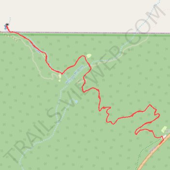
Walls of Jericho Hiking Trail
- Distance: 10.8 Km
- Elevation gain: 460 m
- Maximum elevation: 544 m
- Elevation loss: 453 m
- Minimum elevation: 220 m
- Moving time: 3 h 23 m
- Moving speed: 3.2 Km/h
- Maximum speed: 37.9 Km/h
- Total time: 6 h 5 m
- Global speed: 1.8 Km/h
Interactive trail map
Trail profile
- Distance: 10.8 Km
- Elevation gain: 460 m
- Maximum elevation: 544 m
- Elevation loss: 453 m
- Minimum elevation: 220 m
- Moving time: 3 h 23 m
- Moving speed: 3.2 Km/h
- Maximum speed: 37.9 Km/h
- Total time: 6 h 5 m
- Global speed: 1.8 Km/h
About this trail
Name: Walls of Jericho Hiking Trail trail, distance, elevation, map, profile, GPS track
Start: Walls of Jericho Trail, Jericho, Jackson County, Alabama, United States (34.97754 -86.08189)
End: AL 79, Hytop, Jackson County, Alabama, United States (34.97580 -86.08089)
Coordinates: 34.97580 -86.10415 34.99065 -86.08025
Other hiking, mountain biking, running and outdoor activity trails
Click on a trail to view its statistics, map and profile.
Walls of Jericho Trail in James D. Martin Skyline Wildlife Management Area
United States > Alabama > Jackson County > Skyline
The Walls of Jericho Trail offers a striking and immersive hiking experience. Starting from the Alabama trailhead, the hike is characterized by its challenging descent into a gorge framed by towering limestone cliffs. Along the way, hikers traverse various creek crossings, pass through a historic cemetery, and…
Distance: 10.7 Km • Elevation gain: 448 m • Maximum elevation: 542 m
Gmaps Pedometer Route
United States > Kentucky > Fulton County > Hickman
Distance: 502.9 Km • Elevation gain: 4,204 m • Maximum elevation: 592 m