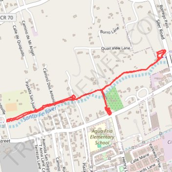
Santa Fe Greenway River Trail
- Distance: 4.1 Km
- Elevation gain: 40 m
- Maximum elevation: 2,034 m
- Elevation loss: 40 m
- Minimum elevation: 2,011 m
- Moving time: 54 m 59 s
- Moving speed: 4.4 Km/h
- Maximum speed: 16.2 Km/h
- Total time: 55 m 33 s
- Global speed: 4.4 Km/h
Interactive trail map
Trail profile
- Distance: 4.1 Km
- Elevation gain: 40 m
- Maximum elevation: 2,034 m
- Elevation loss: 40 m
- Minimum elevation: 2,011 m
- Moving time: 54 m 59 s
- Moving speed: 4.4 Km/h
- Maximum speed: 16.2 Km/h
- Total time: 55 m 33 s
- Global speed: 4.4 Km/h
About this trail
Name: Santa Fe Greenway River Trail trail, distance, elevation, map, profile, GPS track
Start: Agua Fria Street, Agua Fria, Santa Fe County, New Mexico, 87507, United States (35.66099 -106.00309)
End: Agua Fria Street, Agua Fria, Santa Fe County, New Mexico, 87507, United States (35.66084 -106.00313)
Coordinates: 35.66031 -106.01220 35.66544 -105.99815