
Hollow Tree Trail - Big Basin Redwoods State Park
- Distance: 17.4 Km
- Elevation gain: 571 m
- Maximum elevation: 693 m
- Elevation loss: 571 m
- Minimum elevation: 324 m
Interactive trail map
Trail profile
- Distance: 17.4 Km
- Elevation gain: 571 m
- Maximum elevation: 693 m
- Elevation loss: 571 m
- Minimum elevation: 324 m
About this trail
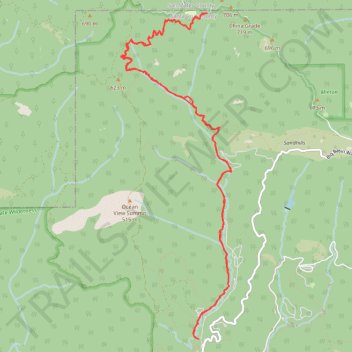
Name: Hollow Tree Trail - Big Basin Redwoods State Park trail, distance, elevation, map, profile, GPS track
Start: North Escape Road, Santa Cruz County, California, United States (37.17307 -122.22275)
End: North Escape Road, Santa Cruz County, California, United States (37.17305 -122.22276)
Coordinates: 37.17305 -122.23525 37.21457 -122.21755
Other hiking, mountain biking, running and outdoor activity trails
Click on a trail to view its statistics, map and profile.
Silver Falls via Sunset Trail in Big Basin Redwoods State Park
United States > California > Santa Cruz County
The Sunset Trail offers a scenic and rewarding hiking experience, leading to three distinct waterfalls: Silver Falls, The Cascades, and Golden Falls. Along the way, hikers will be immersed in lush redwood forests, crossing over cool streams and ascending rocky terrain. The trail provides views of these…
Distance: 7.5 Km • Elevation gain: 362 m • Maximum elevation: 434 m
Big Basin Redwoods Hike via Skyline to the Sea, Sunset, Middle Ridge, Hihn Hammond and Mount McAbee Overlook
United States > California > Santa Cruz County
Distance: 10.6 Km • Elevation gain: 448 m • Maximum elevation: 517 m
Big Basin Redwoods State Park - Creeping Forest, Middle Ridge, Ocean View Summit, Hihn Hammond
United States > California > Santa Cruz County
Distance: 16.5 Km • Elevation gain: 576 m • Maximum elevation: 696 m