Thank you for supporting this site ❤️
Make a donation
Make a donation
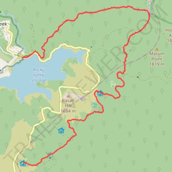
Falls Creek Hiking
- Distance: 16.1 Km
- Elevation gain: 411 m
- Maximum elevation: 1,777 m
- Elevation loss: 337 m
- Minimum elevation: 1,585 m
- Moving time: 4 h 1 m
- Moving speed: 4.0 Km/h
- Maximum speed: 5.5 Km/h
- Total time: 4 h 38 m
- Global speed: 3.5 Km/h
Interactive trail map
Thank you for supporting this site ❤️
Make a donation
Make a donation
Trail profile
- Distance: 16.1 Km
- Elevation gain: 411 m
- Maximum elevation: 1,777 m
- Elevation loss: 337 m
- Minimum elevation: 1,585 m
- Moving time: 4 h 1 m
- Moving speed: 4.0 Km/h
- Maximum speed: 5.5 Km/h
- Total time: 4 h 38 m
- Global speed: 3.5 Km/h
Thank you for supporting this site ❤️
Make a donation
Make a donation
About this trail
Name: Falls Creek Hiking trail, distance, elevation, map, profile, GPS track
Start: Bogong High Plains Road, Falls Creek, Alpine Shire, Victoria, Australia (-36.87428 147.29229)
End: Cope Hut, Cope Hut Track, Nelse, Shire of East Gippsland, Victoria, Australia (-36.90663 147.29260)
Coordinates: -36.90744 147.29227 -36.85818 147.34141
Thank you for supporting this site ❤️
Make a donation
Make a donation
Other hiking, mountain biking, running and outdoor activity trails
Click on a trail to view its statistics, map and profile.
Falls Creek Hiking
Distance: 11.3 Km • Elevation gain: 294 m • Maximum elevation: 1,879 m
Falls Creek Hiking
Distance: 11.8 Km • Elevation gain: 313 m • Maximum elevation: 1,809 m
Thank you for supporting this site ❤️
Make a donation
Make a donation
Nelse Hiking
Distance: 10.2 Km • Elevation gain: 191 m • Maximum elevation: 1,864 m
Nelse Hiking
Distance: 15.0 Km • Elevation gain: 395 m • Maximum elevation: 1,826 m