Cascade Mountain Trail to Cascade Mountain and Porter Mountain in High Peaks Wilderness
The hike along the Cascade Mountain Trail to both Cascade and Porter Mountains offers a rewarding experience with breathtaking views of the surrounding Adirondack peaks and Lake Champlain. The well-maintained trail features a gradual ascent with rocky sections that culminate in stunning panoramic vistas from the summits, making it a favorite among hikers year-round. Notably, the summit of Cascade Mountain is exposed and can be quite windy, while the slightly less popular Porter Mountain provides a unique perspective of the High Peaks region. #Hiking #Mountain #Rock #Forest #Nature
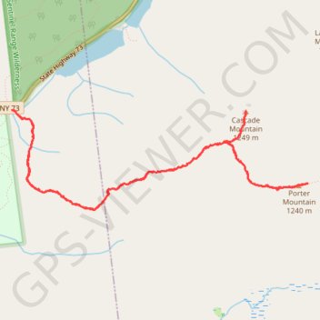
- Distance: 9.6 Km
- Elevation gain: 668 m
- Maximum elevation: 1,226 m
- Elevation loss: 667 m
- Minimum elevation: 661 m
- Moving time: 4 h 38 s
- Moving speed: 2.4 Km/h
- Maximum speed: 6.9 Km/h
- Total time: 6 h 23 m
- Global speed: 1.5 Km/h
Interactive trail map
Trail profile
- Distance: 9.6 Km
- Elevation gain: 668 m
- Maximum elevation: 1,226 m
- Elevation loss: 667 m
- Minimum elevation: 661 m
- Moving time: 4 h 38 s
- Moving speed: 2.4 Km/h
- Maximum speed: 6.9 Km/h
- Total time: 6 h 23 m
- Global speed: 1.5 Km/h
About this trail
Name: Cascade Mountain Trail to Cascade Mountain and Porter Mountain in High Peaks Wilderness trail, distance, elevation, map, profile, GPS track
Coordinates: 44.21030 -73.88756 44.21877 -73.85288
Other hiking, mountain biking, running and outdoor activity trails
Click on a trail to view its statistics, map and profile.
Cascade Mountain Trail in High Peaks Wilderness
United States > New York > Essex County > Town of Keene
The Cascade Mountain Trail in the Adirondacks offers hikers a moderately challenging ascent through dense forests, leading to a bald summit with panoramic views of the surrounding High Peaks. Along the route, hikers can observe the diverse flora of the Adirondack Park and, upon reaching the summit, enjoy…
Distance: 7.2 Km • Elevation gain: 565 m • Maximum elevation: 1,226 m
Cascade Mountain and Porter Mountain
United States > New York > Essex County > Town of Keene
High Peaks Wilderness. #Hiking #Snowshoeing #Mountain #Forest #Nature
Distance: 9.1 Km • Elevation gain: 671 m • Maximum elevation: 1,225 m