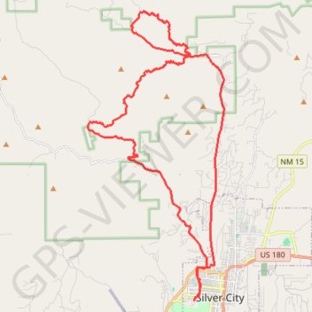
Loop around Eighty Mountain
MTB loop from Silver City at the foot of Eighty Mountain, Stewart Peak, Gomez Peak and Round Mountain in the Gila National Forest. #MTB #Loop #City #Nature #Mountain #Forest
- Distance: 40.6 Km
- Elevation gain: 634 m
- Maximum elevation: 2,052 m
- Elevation loss: 634 m
- Minimum elevation: 1,810 m
- Moving time: 2 h 40 m
- Moving speed: 15.2 Km/h
- Maximum speed: 41.2 Km/h
- Total time: 2 h 52 m
- Global speed: 14.1 Km/h
Interactive trail map
Trail profile
- Distance: 40.6 Km
- Elevation gain: 634 m
- Maximum elevation: 2,052 m
- Elevation loss: 634 m
- Minimum elevation: 1,810 m
- Moving time: 2 h 40 m
- Moving speed: 15.2 Km/h
- Maximum speed: 41.2 Km/h
- Total time: 2 h 52 m
- Global speed: 14.1 Km/h
About this trail
Name: Loop around Eighty Mountain trail, distance, elevation, map, profile, GPS track
Coordinates: 32.77004 -108.33626 32.87943 -108.27447
Other hiking, mountain biking, running and outdoor activity trails
Click on a trail to view its statistics, map and profile.
San Vicente RR, Camino de Viento
United States > New Mexico > Grant County > Silver City
Morning Ride
Distance: 32.6 Km • Elevation gain: 599 m • Maximum elevation: 1,979 m