
Hanging Lake
Starting beside the Colorado River in Glenwood Canyon, the route leaves the canyon floor and enters Dead Horse Creek Canyon, climbing into the White River National Forest.
The ascent follows a shaded, rocky gorge with footbridges, creek crossings, switchbacks, rock steps, and fire-marked canyon scenery before tightening toward the upper basin.
It finishes at the boardwalk around turquoise Hanging Lake, a travertine lake fed by Bridal Veil Falls, with Spouting Rock just above as the final waterfall highlight.
#Hiking #Lake #River #Forest #Canyon #Mountain #Nature #Colorado #Creek #Gorge #Waterfall #Falls #Rock #Wilderness
- Distance: 5.0 Km
- Elevation gain: 378 m
- Maximum elevation: 2,224 m
- Elevation loss: 378 m
- Minimum elevation: 1,866 m
Interactive trail map
Trail profile
- Distance: 5.0 Km
- Elevation gain: 378 m
- Maximum elevation: 2,224 m
- Elevation loss: 378 m
- Minimum elevation: 1,866 m
About this trail
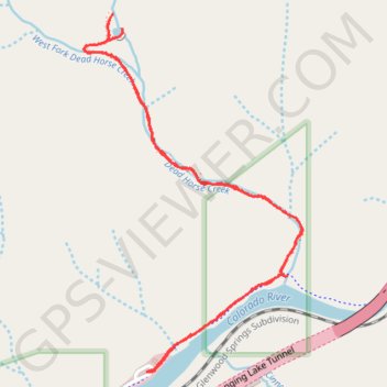
Name: Hanging Lake trail, distance, elevation, map, profile, GPS track
Coordinates: 39.58921 -107.19331 39.60202 -107.18316
Other hiking, mountain biking, running and outdoor activity trails
Click on a trail to view its statistics, map and profile.
Hanging Lake Trail in White River National Forest
United States > Colorado > Garfield County
The Hanging Lake Trail offers an unforgettable hiking experience in Colorado's White River National Forest. The route follows a scenic canyon, with lush greenery and multiple footbridges crossing over Dead Horse Creek, leading to the striking turquoise lake. As you reach the top, you're rewarded with a…
Distance: 2.2 Km • Elevation gain: 331 m • Maximum elevation: 2,199 m