
Pisgah National Forest Run Loop
Loop run / trail / hike from Rice Pinnacle Parking via Wolf Branch Trail, Ingles Fields Gap, Little Hickory Top, Sidehill Trail, Greens Lick Trail, North Boundary Road, Wolf Knob, Mease Gap, Moors Gap, Corvair Trail and Deer Lake Road in the Pisgah National Forest. #Running #Trail #Hiking #Loop #Forest #Nature
- Distance: 23.1 Km
- Elevation gain: 907 m
- Maximum elevation: 1,015 m
- Elevation loss: 907 m
- Minimum elevation: 659 m
- Moving time: 2 h 15 m
- Moving speed: 10.2 Km/h
- Maximum speed: 36.9 Km/h
- Total time: 2 h 25 m
- Global speed: 9.5 Km/h
Interactive trail map
Trail profile
- Distance: 23.1 Km
- Elevation gain: 907 m
- Maximum elevation: 1,015 m
- Elevation loss: 907 m
- Minimum elevation: 659 m
- Moving time: 2 h 15 m
- Moving speed: 10.2 Km/h
- Maximum speed: 36.9 Km/h
- Total time: 2 h 25 m
- Global speed: 9.5 Km/h
About this trail
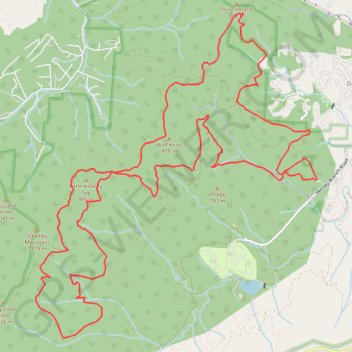
Name: Pisgah National Forest Run Loop trail, distance, elevation, map, profile, GPS track
Coordinates: 35.47600 -82.66002 35.51801 -82.61547