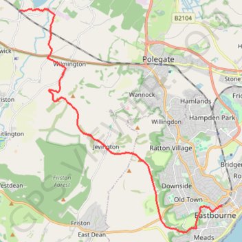
Walk Berwick to Eastbourn
- Distance: 18.0 Km
- Elevation gain: 366 m
- Maximum elevation: 198 m
- Elevation loss: 385 m
- Minimum elevation: 5 m
- Moving time: 3 h 37 m
- Moving speed: 5.0 Km/h
- Maximum speed: 9.0 Km/h
- Total time: 4 h 28 m
- Global speed: 4.0 Km/h
Interactive trail map
Trail profile
- Distance: 18.0 Km
- Elevation gain: 366 m
- Maximum elevation: 198 m
- Elevation loss: 385 m
- Minimum elevation: 5 m
- Moving time: 3 h 37 m
- Moving speed: 5.0 Km/h
- Maximum speed: 9.0 Km/h
- Total time: 4 h 28 m
- Global speed: 4.0 Km/h
About this trail
Name: Walk Berwick to Eastbourn trail, distance, elevation, map, profile, GPS track
Start: Station Road, Berwick, Wealden, East Sussex, England, BN26 6TA, United Kingdom (50.84061 0.16606)
Coordinates: 50.75995 0.16606 50.84117 0.28214