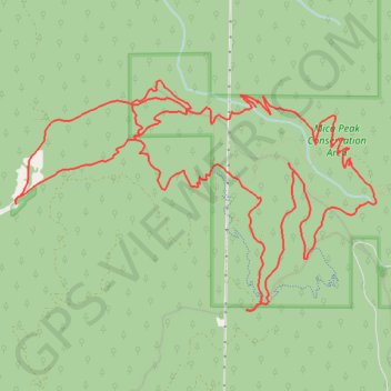
Mica Peak Conservation Area hike
- Distance: 19.2 Km
- Elevation gain: 743 m
- Maximum elevation: 1,381 m
- Elevation loss: 743 m
- Minimum elevation: 828 m
- Moving time: 3 h 59 m
- Moving speed: 4.8 Km/h
- Maximum speed: 11.9 Km/h
- Total time: 5 h 21 m
- Global speed: 3.6 Km/h
Interactive trail map
Trail profile
- Distance: 19.2 Km
- Elevation gain: 743 m
- Maximum elevation: 1,381 m
- Elevation loss: 743 m
- Minimum elevation: 828 m
- Moving time: 3 h 59 m
- Moving speed: 4.8 Km/h
- Maximum speed: 11.9 Km/h
- Total time: 5 h 21 m
- Global speed: 3.6 Km/h
About this trail
Name: Mica Peak Conservation Area hike trail, distance, elevation, map, profile, GPS track
Coordinates: 47.56534 -117.13547 47.58509 -117.08960