Import a GPX file

Berrinba Wetlands Nature Refuge

#Hiking #Loop #Berrinba

  • Distance: 1.8 Km
  • Elevation gain: 9 m
  • Maximum elevation: 19 m
  • Elevation loss: 10 m
  • Minimum elevation: 12 m
  • Moving time: 21 m 22 s
  • Moving speed: 5.0 Km/h
  • Maximum speed: 13.4 Km/h
  • Total time: 23 m 1 s
  • Global speed: 4.7 Km/h

Interactive trail map

Trail profile

  • Distance: 1.8 Km
  • Elevation gain: 9 m
  • Maximum elevation: 19 m
  • Elevation loss: 10 m
  • Minimum elevation: 12 m
  • Moving time: 21 m 22 s
  • Moving speed: 5.0 Km/h
  • Maximum speed: 13.4 Km/h
  • Total time: 23 m 1 s
  • Global speed: 4.7 Km/h

About this trail
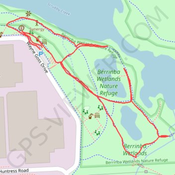
Name: Berrinba Wetlands Nature Refuge trail, distance, elevation, map, profile, GPS track

Start: Wayne Goss Drive, Berrinba, Greater Brisbane, Queensland, 4117, Australia (-27.66652 153.07829)

End: Wayne Goss Drive, Berrinba, Greater Brisbane, Queensland, 4117, Australia (-27.66648 153.07835)

Coordinates: -27.66912 153.07738 -27.66575 153.08178

Gear up for your next adventure:

🥣Outdoor Food & Meals - Dehydrated meals for backpacking
📡Satellite Messengers - Emergency communication for remote areas without signal
🔋Solar Power Banks - Keep your GPS and phone charged in the Irish wilderness
🗺️Irish Road Atlases - Comprehensive physical maps for road trips and navigation
🗺️Topographic Maps - Detailed maps for hiking, cycling and planning routes

As an Amazon Associate, this site earns from qualifying purchases at no extra cost to you.