
Sleeping Giant Loop via Blue Trail and Tower Path
This Sleeping Giant Loop offers a fantastic blend of scenic vistas and engaging terrain. As hikers ascend, they are treated to breathtaking views from various overlooks, where on clear days, the expanse stretches all the way to Long Island Sound. The trail features rocky scrambles that add a thrilling element to the journey, culminating at the stone tower which provides even more panoramic views, making it a rewarding hike for both novice and experienced outdoor enthusiasts. #Hiking #Loop #Forest #Nature #Rock
- Distance: 5.1 Km
- Elevation gain: 234 m
- Maximum elevation: 215 m
- Elevation loss: 227 m
- Minimum elevation: 36 m
- Moving time: 1 h 35 m
- Moving speed: 3.2 Km/h
- Maximum speed: 5.7 Km/h
- Total time: 2 h 12 m
- Global speed: 2.3 Km/h
Interactive trail map
Trail profile
- Distance: 5.1 Km
- Elevation gain: 234 m
- Maximum elevation: 215 m
- Elevation loss: 227 m
- Minimum elevation: 36 m
- Moving time: 1 h 35 m
- Moving speed: 3.2 Km/h
- Maximum speed: 5.7 Km/h
- Total time: 2 h 12 m
- Global speed: 2.3 Km/h
About this trail
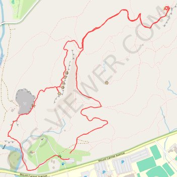
Name: Sleeping Giant Loop via Blue Trail and Tower Path trail, distance, elevation, map, profile, GPS track
Coordinates: 41.42071 -72.90348 41.43076 -72.89026
Other hiking, mountain biking, running and outdoor activity trails
Click on a trail to view its statistics, map and profile.

Sleeping Giant Tower Trail in Sleeping Giant State Park
United States > Connecticut > South Central Connecticut Planning Region > Hamden
The Sleeping Giant Tower Trail offers an engaging hiking experience with picturesque views and historical features. As you ascend, the trail meanders through lush woodlands and rocky outcrops, leading to a stunning stone tower that provides expansive vistas of the surrounding landscape, including distant views…
Distance: 5.0 Km • Elevation gain: 183 m • Maximum elevation: 211 m