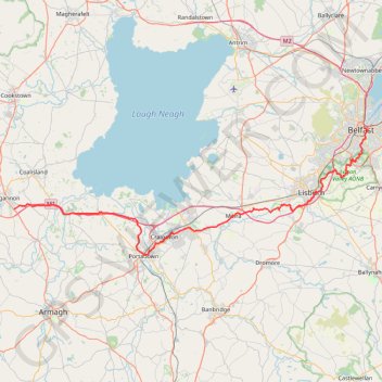
Belfast to Dungannon
Bicycle ride from Belfast Big Fish to Dungannon.
- Distance: 83.3 Km
- Elevation gain: 549 m
- Maximum elevation: 75 m
- Elevation loss: 494 m
- Minimum elevation: 0 m
- Moving time: 4 h 7 m
- Moving speed: 20.2 Km/h
- Maximum speed: 52.8 Km/h
- Total time: 5 h 52 m
- Global speed: 14.2 Km/h
Interactive trail map
Trail profile
- Distance: 83.3 Km
- Elevation gain: 549 m
- Maximum elevation: 75 m
- Elevation loss: 494 m
- Minimum elevation: 0 m
- Moving time: 4 h 7 m
- Moving speed: 20.2 Km/h
- Maximum speed: 52.8 Km/h
- Total time: 5 h 52 m
- Global speed: 14.2 Km/h
About this trail
Name: Belfast to Dungannon trail, distance, elevation, map, profile, GPS track
Coordinates: 54.42456 -6.74527 54.60128 -5.91393
Other hiking, mountain biking, running and outdoor activity trails
Click on a trail to view its statistics, map and profile.
CTS-N.Irelandv1.1-Belfast-Titanic>Enniscrone-via antrim coast-209miles
United Kingdom > Northern Ireland > County Down > Belfast
Distance: 335.8 Km • Elevation gain: 3,985 m • Maximum elevation: 271 m
Newry Canal Towpath
United Kingdom > Northern Ireland > County Armagh > Portadown
Distance: 32.3 Km • Elevation gain: 95 m • Maximum elevation: 29 m
Cycle up Divis and Black Mountain
United Kingdom > Northern Ireland > County Down > Belfast
Divis, Black Mountain, Cycle, Bicycle
Distance: 26.7 Km • Elevation gain: 426 m • Maximum elevation: 383 m
Forth Meadows Greenway, Belfast
United Kingdom > Northern Ireland > County Down > Belfast
Cycling
Distance: 25.4 Km • Elevation gain: 233 m • Maximum elevation: 78 m
Lagan & Lough
United Kingdom > Northern Ireland > County Antrim > Tullynacross
Distance: 29.4 Km • Elevation gain: 153 m • Maximum elevation: 35 m