Dunrod Hill and Hillside Hill loop from Greenock West - Clyde Muirshiel Regional Park
- Distance: 18.9 Km
- Elevation gain: 410 m
- Maximum elevation: 291 m
- Elevation loss: 409 m
- Minimum elevation: 16 m
- Moving time: 1 h 41 m
- Moving speed: 11.2 Km/h
- Maximum speed: 21.9 Km/h
- Total time: 1 h 43 m
- Global speed: 11.0 Km/h
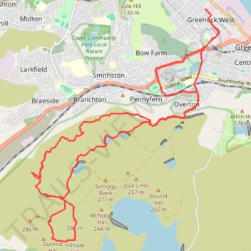
Interactive trail map
Trail profile
- Distance: 18.9 Km
- Elevation gain: 410 m
- Maximum elevation: 291 m
- Elevation loss: 409 m
- Minimum elevation: 16 m
- Moving time: 1 h 41 m
- Moving speed: 11.2 Km/h
- Maximum speed: 21.9 Km/h
- Total time: 1 h 43 m
- Global speed: 11.0 Km/h
About this trail
Name: Dunrod Hill and Hillside Hill loop from Greenock West - Clyde Muirshiel Regional Park trail, distance, elevation, map, profile, GPS track
Coordinates: 55.91375 -4.82402 55.95379 -4.76618
Other hiking, mountain biking, running and outdoor activity trails
Click on a trail to view its statistics, map and profile.