Fledermauswald
Loop from Ennigerloh.
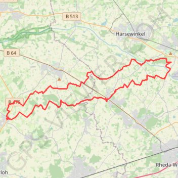
- Distance: 49.9 Km
- Elevation gain: 114 m
- Maximum elevation: 83 m
- Elevation loss: 114 m
- Minimum elevation: 61 m
Interactive trail map
Trail profile
- Distance: 49.9 Km
- Elevation gain: 114 m
- Maximum elevation: 83 m
- Elevation loss: 114 m
- Minimum elevation: 61 m
About this trail
Name: Fledermauswald trail, distance, elevation, map, profile, GPS track
Coordinates: 51.88340 8.04303 51.93921 8.28581
Other hiking, mountain biking, running and outdoor activity trails
Click on a trail to view its statistics, map and profile.
Görlitz - Alpen
Germany > Saxony > Görlitz > Görlitz
Distance: 749.5 Km • Elevation gain: 5,160 m • Maximum elevation: 446 m
Görlitz - Alpen
Germany > Saxony > Görlitz > Görlitz
Distance: 749.5 Km • Elevation gain: 5,160 m • Maximum elevation: 446 m
Eurovelo 15 - Strasbourg Rotterdam
France > Grand Est > Bas-Rhin > Strasbourg
Distance: 891.7 Km • Elevation gain: 2,104 m • Maximum elevation: 146 m
PT23BS1 Kiel → Lörrach
Germany > Schleswig-Holstein > Kiel
Distance: 1,046.7 Km • Elevation gain: 9,265 m • Maximum elevation: 757 m