NEW TMB5
Length: 11.58 km (7.195 mi)
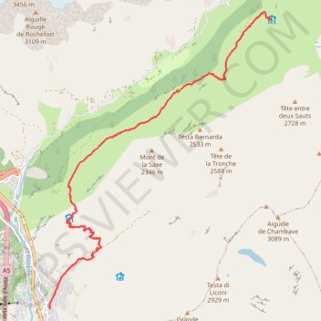
- Distance: 11.7 Km
- Elevation gain: 1,115 m
- Maximum elevation: 2,041 m
- Elevation loss: 319 m
- Minimum elevation: 1,224 m
Interactive trail map
Trail profile
- Distance: 11.7 Km
- Elevation gain: 1,115 m
- Maximum elevation: 2,041 m
- Elevation loss: 319 m
- Minimum elevation: 1,224 m
About this trail
Name: NEW TMB5 trail, distance, elevation, map, profile, GPS track
Start: Via Roma, Pussey, Courmayeur, Aosta Valley, 11013, Italy (45.79135 6.97280)
Coordinates: 45.79135 6.97252 45.84822 7.03359
Other hiking, mountain biking, running and outdoor activity trails
Click on a trail to view its statistics, map and profile.
Ultra-Trail du Mont Blanc (UTMB)
France > Auvergne-Rhône-Alpes > Upper Savoy > Chamonix-Mont-Blanc
Distance: 167.8 Km • Elevation gain: 10,450 m • Maximum elevation: 2,535 m
UTMB 2020
France > Auvergne-Rhône-Alpes > Upper Savoy > Chamonix-Mont-Blanc > Les Bossons
Total: 171.3km
Distance: 168.1 Km • Elevation gain: 10,526 m • Maximum elevation: 2,574 m
TTdMB-1 Tour Du Mont Blanc - Itinéraire Principal
France > Auvergne-Rhône-Alpes > Upper Savoy > Chamonix-Mont-Blanc
Distance: 166.0 Km • Elevation gain: 10,535 m • Maximum elevation: 2,537 m
PT23DS2 Lörrach → Cadaqués
Germany > Baden-Württemberg > Landkreis Lörrach > Lörrach (Kernstadt)
Distance: 1,050.7 Km • Elevation gain: 13,130 m • Maximum elevation: 1,505 m