Thank you for supporting this site ❤️
Make a donation
Make a donation
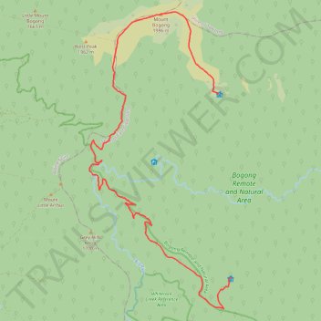
Nelse Hiking
- Distance: 23.2 Km
- Elevation gain: 1,031 m
- Maximum elevation: 1,984 m
- Elevation loss: 1,097 m
- Minimum elevation: 1,215 m
- Moving time: 6 h 41 m
- Moving speed: 3.5 Km/h
- Maximum speed: 5.4 Km/h
- Total time: 8 h 51 m
- Global speed: 2.6 Km/h
Interactive trail map
Thank you for supporting this site ❤️
Make a donation
Make a donation
Trail profile
- Distance: 23.2 Km
- Elevation gain: 1,031 m
- Maximum elevation: 1,984 m
- Elevation loss: 1,097 m
- Minimum elevation: 1,215 m
- Moving time: 6 h 41 m
- Moving speed: 3.5 Km/h
- Maximum speed: 5.4 Km/h
- Total time: 8 h 51 m
- Global speed: 2.6 Km/h
Thank you for supporting this site ❤️
Make a donation
Make a donation
About this trail
Name: Nelse Hiking trail, distance, elevation, map, profile, GPS track
Start: Long Spur, Nelse, Shire of East Gippsland, Victoria, Australia (-36.75617 147.32732)
Coordinates: -36.81920 147.27959 -36.73172 147.33197
Thank you for supporting this site ❤️
Make a donation
Make a donation
Other hiking, mountain biking, running and outdoor activity trails
Click on a trail to view its statistics, map and profile.
Falls Creek Hiking
Distance: 11.3 Km • Elevation gain: 294 m • Maximum elevation: 1,879 m
Nelse Hiking
Distance: 10.2 Km • Elevation gain: 191 m • Maximum elevation: 1,864 m
Thank you for supporting this site ❤️
Make a donation
Make a donation
Nelse Hiking
Distance: 12.5 Km • Elevation gain: 888 m • Maximum elevation: 1,770 m