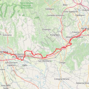
2022_DE_Verona-Vicenza | flach
- Distance: 73.2 Km
- Elevation gain: 471 m
- Maximum elevation: 159 m
- Elevation loss: 486 m
- Minimum elevation: 30 m
Interactive trail map
Trail profile
- Distance: 73.2 Km
- Elevation gain: 471 m
- Maximum elevation: 159 m
- Elevation loss: 486 m
- Minimum elevation: 30 m
About this trail
Name: 2022_DE_Verona-Vicenza | flach trail, distance, elevation, map, profile, GPS track
Start: Via degli Alpini, San Zeno, Centro Storico, Verona, Veneto, 37122, Italy (45.43837 10.99170)
Coordinates: 45.39791 10.99170 45.54706 11.54734
Other hiking, mountain biking, running and outdoor activity trails
Click on a trail to view its statistics, map and profile.
2022_DE_Peschiera-Verona
Italy > Veneto > Verona > Peschiera del Garda
Distance: 34.0 Km • Elevation gain: 278 m • Maximum elevation: 190 m
2022_DE_Vicenza-Thermengebiet
Italy > Veneto > Vicenza > Vicenza
Distance: 50.4 Km • Elevation gain: 193 m • Maximum elevation: 53 m