Thank you for supporting this site ❤️
Make a donation
Make a donation
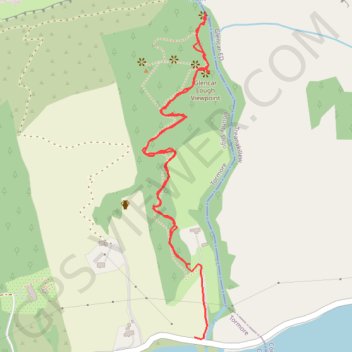
The Devils Chimney
- Distance: 2.1 Km
- Elevation gain: 114 m
- Maximum elevation: 163 m
- Elevation loss: 131 m
- Minimum elevation: 31 m
- Moving time: 29 m 53 s
- Moving speed: 4.2 Km/h
- Maximum speed: 18.7 Km/h
- Total time: 45 m 54 s
- Global speed: 2.7 Km/h
Interactive trail map
Thank you for supporting this site ❤️
Make a donation
Make a donation
Trail profile
- Distance: 2.1 Km
- Elevation gain: 114 m
- Maximum elevation: 163 m
- Elevation loss: 131 m
- Minimum elevation: 31 m
- Moving time: 29 m 53 s
- Moving speed: 4.2 Km/h
- Maximum speed: 18.7 Km/h
- Total time: 45 m 54 s
- Global speed: 2.7 Km/h
Thank you for supporting this site ❤️
Make a donation
Make a donation
About this trail
Name: The Devils Chimney trail, distance, elevation, map, profile, GPS track
End: Glencar ED, Sligo Municipal Borough District, County Sligo, Connacht, Ireland (54.34051 -8.39317)
Coordinates: 54.34047 -8.39494 54.34692 -8.39265
Topography: County Sligo topographic map, elevation, terrain
Thank you for supporting this site ❤️
Make a donation
Make a donation
Other hiking, mountain biking, running and outdoor activity trails
Click on a trail to view its statistics, map and profile.
CTS-N.Irelandv1.1-Belfast-Titanic>Enniscrone-via antrim coast-209miles
United Kingdom > Northern Ireland > County Down > Belfast
Distance: 335.8 Km • Elevation gain: 3,985 m • Maximum elevation: 271 m